River Report: Low Water and Carp Die-Off
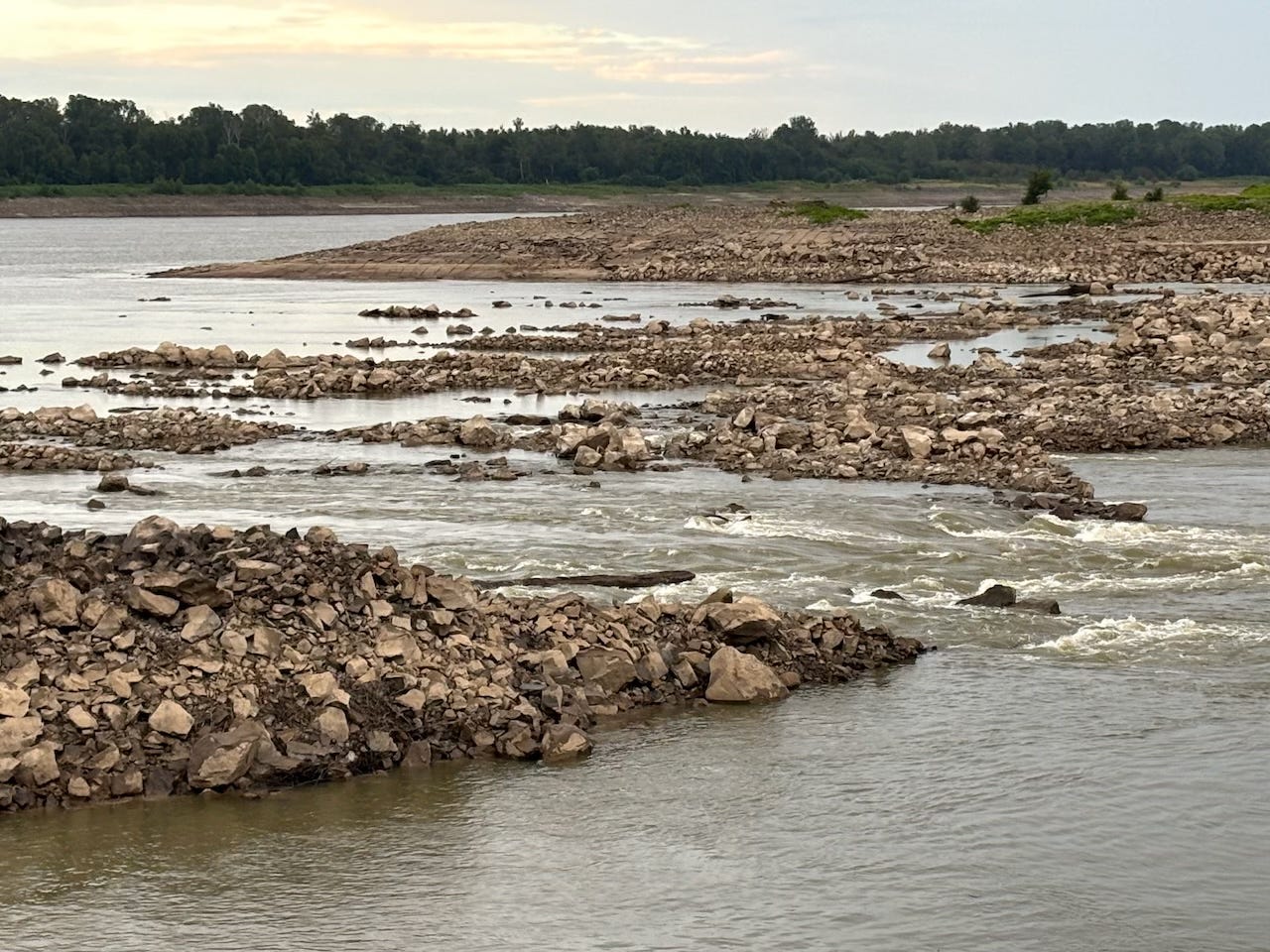
The big river has fallen 4 feet in the last week, and is now approaching zero --0--on the Helena Gage (HG). This is about as low as it gets around here. We seem to be heading into another low water autumn. Connecting wetlands and lakes are heating up, losing oxygen, and suffering a massive bighead carp die-off. Algal growth blooming. Retreating water being sucked back into big river is also sucking thousands of dead fish alongside. No other fish species seem to be dying off. You will find endless campsites, but watch out for unexpected wind & rain storms. And camp away from any washed up carp. Or bury them.
Upcoming Trips You Can Join in On:

*New Moon All-Nighter Thursday Sept 5
*New Moon All-Nighter Saturday Sept 7
(Start sunset, all nighter, end at sunrise next day)

*Community Canoe, Sat Sept 14
(from Quapaw Landing)
Driftwood Johnnie’s River Log ~ Muddy Waters Wilderness ~ Aug 31-Sept 2, 2024
Sat Aug 31, Close to Heaven on Island 67: coyote clans and owls calling back & forth between the broad forestlands of Is. 66 and the smaller stands opposite near Keith’s Landing, the great horned getting horny, mating season, coupling up, barred owls squabbling amongst the sexes as they “work it out,” the enchanting titillating of the screech owl warbling melismatically in between like a warbling whistling alien. But this is nature. This is their home. We are the aliens. Creation is alive.
We are camped in between forests on island Sixty-Seven which rises like a whale’s backbone out of the middle of the river. We put in late morning at Quapaw, bank swallows following us out back channel 63, egrets at Modoc, herons throughout, some fresh beaver chews on 67, foster’s tern around 68, river otter trails, and a black bear sighting on Big Island. Many moths and butterflies in motion, viceroy butterflies (monarch mimic) fluttering around willow forests throughout, trumpet vine flower in full gaudy orange-red bloom, a few hummingbirds. I have been wondering all summer where the owls were, and the coyotes. So here they are! What a relief! But now I am wondering where are the eagles? And the beavers? We have not seen any eagles. Yet. Or beavers. Beavers are having a tough time in this prolonged low water. So tender is the fragile lifeline of creation. Every time I see a monarch or hear a drum roll under the canoe (from the drum fish), I wonder if it will be the last — a lurching fear that hits with a poignant palpitating pang in my heart. Fortunately nature is more resilient than the pangs of my heart.
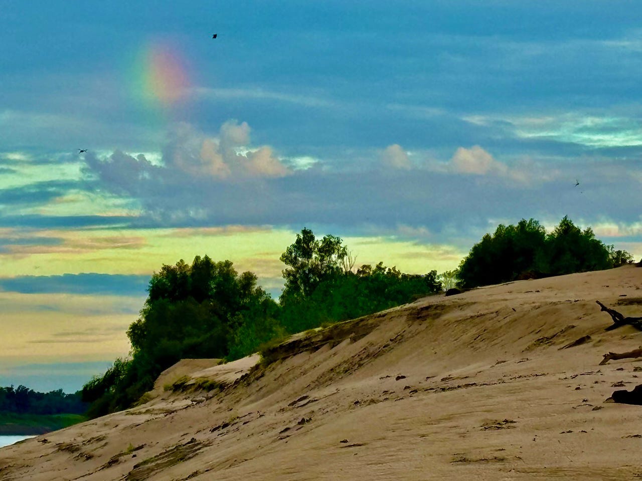
Soft diffuse rainbow at sunrise which Ceili and then Marc seem to walk out of on their route from cottonwood grove tent site high on the ridge down to the kitchen (like the “rainbow rider” from “Jeremiah was a Bullfrog”). So subtle of an apparition seemingly glowing from within as the sun’s rays are not visible anywhere. Fire started and river rat cowboy coffee ready, we are sitting around in circle when three kayaks appear around the bend and carefully hug the shore barely in the current, and cautiously approach our location. I give a banshee holler and swim out to greet them. They are vet adventurers from the Wounded Warrior Expedition project, who annually offer the Mississippi 3-month as one of the options for recovery and reintroduction to community & society, Lake Itasca to the Gulf, 2300 miles of paddling. What a great way to return. They started out two months ago as a team of six, now they are three, and have one month to go. Three solo paddlers arrive later, one ofter another, the first is kayaker Paul Miller, chatty, funny, and very friendly, followed by another kayaker, Chris Seaman, and still later “Sunshine” JW Francis (Caleb Durham) in a classic Grumman, composing songs as he goes. The fall migration is on. More about them in a later issue.
The river low and getting lower, but still she is full of motion, full of life vibrancy, sparkling life lines shining against dark colored backdrops like forested islands and wet muddy places. Bank Swallows flocking along the whaleback island sand dune ridge, 100s of them, a small flock of geese cross over river from below Jug Harris Island 68, American crows crusty cawing, sweet gentle morning, cool, low clouds.
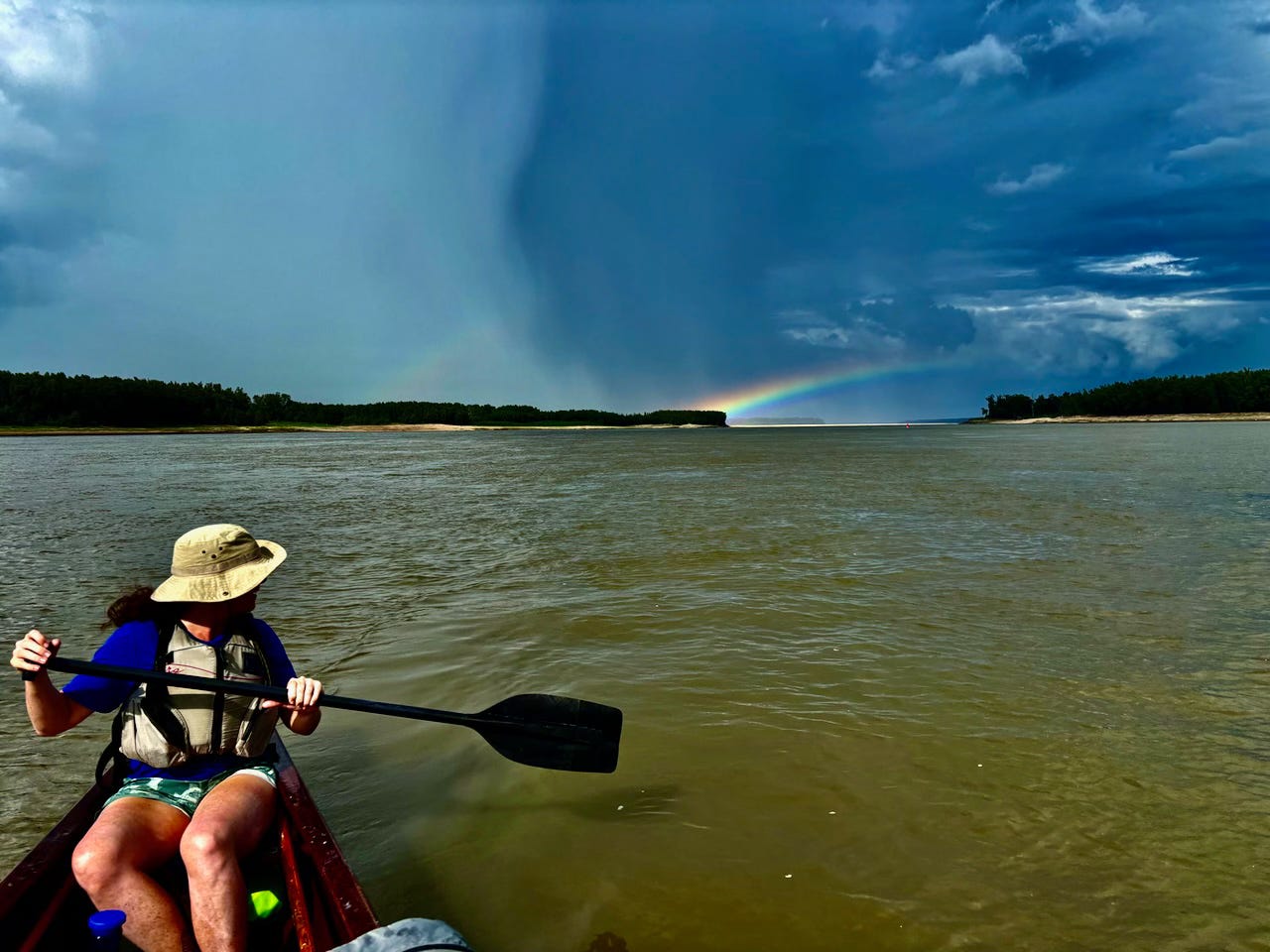
Sun Sept 1, Mouth of the Old White River: at 1HG a roaring whitewater feature over a massive pile of riprap in random disarray, completely chaotic and disrespectful of the character of a deep muddy river. Drum, gar, and other fish rising in front of me, very much alive all the dead carp floating by. I am sitting in sand next to Cricket canoe, my tent, cowboy coffee fire and our camp behind, everything close at hand, my favorite kind of campsite. Dead carp drifting by, a few washing ashore, the only dead fish we have seen floating along have been the big head carp. Apparently they have not learned to exit adjoining wetlands in summer heat low water. We did find one dead Mississippi Map turtle at this camp (I buried); all other turtles were alive. A thick fog drifted in during the night, no doubt the result of the intense thunderstorm that took shape in the late afternoon after we left Island No. 70 gravel bar lunch spot, and made a stunning horizontal rainbow over Scrubgrass.
Here is artist’s impression, stream of consciousness, only commas for punctuation: the long slice of sun-drenched sandbar glowing intensely yellow-white below, the river a slice of steel grey, a slightly curved effervescent rainbow arcing slightly and hovering upward above the river from the mature black willows standing tall and straight on steep muddy bank high ground of island and hanging over the brightly illuminated sandbar and the river, striking in its unusually low and flat curvature and position, maybe due to the low angle end of day light, from our low angle perspective, madly paddling our 24-foot canoe around Smith Point, paddling hard in order to reach our intended campsite around the corner, but repeatedly getting distracted, captivated by the magic glowing bar of color behind us, like an artist’s multi-colored candy bar, anyone with any artistic appreciation or sensibility will get distracted by this kind of magic!
Captain Mayfly (Ceili Hale) deftly handling 24-foot long cypress strip voyageur style Cricket Canoe downstream through the strange confusing conflagration of boiling turbulence and channels that don’t make any sense in the 180-degree big bend at Scrubgrass (Smith Point). Contrary to normal water movements around big bends of the river, today’s paddlers find swift currents hugging the inside of the bend, with slow-moving chaotic turbulence of giant upwelling boils of giant canoe-grabbing eddies along the shoreline outside bend. Scubrgrass has been purposely engineered this way — rendered so raggedly by the construction of underwater weirs for the assistance of upstream tows against what used to be powerful outside edge currents — and the complication of navigation for tows entering mouth of the White River, most headed to the Arkansas River (via McLellan-Kerr Canal for tows traveling to Little Rock, Fort Smith, and on up into Tulsa, Oklahoma, this involves passage through three locks & dams just to get to the Arkansas, and then a series of locks & dams on upstream). Only the Middle and Lower Mississippi remain dam-free due to their gargantuan size and depth. But even the biggest river in North America is experiencing extreme low water conditions throughout the past three drought years 2022, 2023 and now 2024; as result tows have had to reduce cargo and number of barges being pushed.
Meanwhile we paddlers happily carry on mostly unaffected, except with slower water — and stinky dead carp everywhere.
The magic gets frightening: a second rainbow appears in the typical 52-degree position, much fainter but eye-catching in peripheral vision, low, flattened, but slightly more arced, as the looming grey blue ragged guts of the storm edge closer “darker than the inside of a cow” straight-line cylinder clouds rolling outwards perpendicular to storm center indicating the rush of winds below and most alarmingly headed our way, the far line of 150’ tall cottonwood trees (oaks & sweet gums mixed in further back) starting to shake, dust clouds rolling outwards and whipping upwards, whipping into a frenzy of dust, spiraling upwards like hoodoos, dust clouds building over the south bar, we make safe landing at the large dune at mouth of the Old White RBD 595, as winds thrash opposite treeline over Concordia with clouds of boiling leaves thrown upwards, and hit us cross-channel, waves kicked up in the commotion, slapping our safely beached canoe but drenching everything with hard slapping waves, we quickly unpack and pull Cricket up gentle slope out of the water.
We are now on Big Island. No rain until I get fire going and we get tents up. We are lucky. We miss the full fury of the storm being camped slightly southwards of main trajectory, the main thrust of the storm seems to be welling westward over the White River bottomlands. The winds gradually calm down with a very gentle rain that is cool & refreshing, and needs no protection from, a blessing really, like a mister machine on a hot day. We reheat a crawfish okra gumbo I made on land over the fire for supper in smallest Dutch oven, and eat it with rice, green lentils, and garnished with blanched yucca leaves for topping, the sky an eye-catching backdrop of passing storm with re-freshened forests and sandbars, everything sparkling clean, the dust pushed down, the air crystal clear. I take a long walk after supper into the shallow hardened mud layered canyon found at the mouth of the Old White, which separates 4,000 acre Montgomery Island from 20,000 acre Big Island.
It’s amazing how just 50 feet of elevation changes the perspective of the river and surrounding sandbars. Somehow this little change evokes a sensation similar to walking the layers of the profound immensity of the Grand Canyon. The unbroken wall of horizontal layered green forests on the Mississippi becomes the Red Wall of the Grand Canyon, and muddy layers below become the Sipapu and deeper older layering. This feeling gets reinforced as I balance walk along benches formed by the old mud, in places yellow orange, indicative of Arkansas River origin. (Mississippi mud most often dark grey, blues, browns, Arkansas mud hardens in the yellow-orange-red spectrum, revealing its sediment history from red earth Oklahoma, Texas, and southern Kansas.)
The Milky Way that was clearly visible at dark, stretching out in between Sagittarius and Cassiopeia, had settled over the horizon after midnight, followed by layers of thin clouds that slid in layer after layer, eventually snuffing out the starry sky. Orion and Auriga made a showing, Pleiades also, then disappeared in the thickness, a tow glowing in the mist came to stop along shoreline opposite us, awaiting passage of a downstream around Smith Point.
Labor Day, Monday Sept 2: Victoria Bend Wreck and Black Bear on Big Island
(to be continued in next issue…)
Lower Mississippi River Dispatch No. 945
"Voice of the Lower Mississippi River"
 Vicksburg, MS ~ Memphis, TN ~ Clarksdale, MS ~ Wilson, AR
Quapaw Canoe Company ~ Celebrating 26 Years of Service ~
~Winner of the SBA 2024 Small Business of the Year Award~


